Campaign Region: Description; Background; Maps
-
Landifarne
- Pathfinder

- Posts: 283
- Joined: Sat Oct 12, 2013 7:57 pm
- Location: Los Angeles (Miracle Mile)
Campaign Region: Description; Background; Maps
The campaign begins in and about the Djorsalng Valley- a large, forested mountain valley bounded to the north by the hamlet of Highwold, to the south by the village of Rifford, to the west by the Djorsalng Reach, and to the east by the Immrik Mountains. This entire region is claimed by King Lornall of Norlund, and is held in the king's name by Banner Knight Hrothen Duralain (of Highwold) and Eorl Arli Hroxim (Lord of County Osterlic, centered upon the town of Rifford).
-
Landifarne
- Pathfinder
- Posts: 283
- Joined: Sat Oct 12, 2013 7:57 pm
- Location: Los Angeles (Miracle Mile)
Re: Campaign Region: Description; Background; Maps
Possible Starting Locale 1: Highwold and the Djorsalng Pass
Highwold is a rustic mountain village situated at the pinnacle of the forested Djorsalng Valley. Located one day south of the narrow Djorsalng Pass (which is only 50’ wide at its narrowest point), the town acts as a choke point against the wilders and humanoids of the Norwold forest; but it is also very remote, and is cut off from the rest of human civilization. Highwold and its’ surroundings are ruled by Lord Hrothen Duralain, but the region does experience frequent pressure from adjacent peoples and tribes.
To the east of Duralain’s lands lie the mines and tunnels of Highwold’s nominal allies: the dwarves of Hörlenholt. The “stoutfolk” deal fairly with the villagers of Highwold, but stay strictly within their mountain holdfasts except when engaging in mutually beneficial trade. The dwarves tend not to involve themselves with human affairs but, in turn, brook no interference or encroachment from the people or forces of Norlund.
South of the banner knight’s holdings lie the fifteen league expanse of the Djorsalng Valley and, after that, Eorl Hroxim’s extensive and powerful County of Osterlic. Lord Duralain vigorously maintains Highwold’s independence of the Eorl, but this proves increasingly difficult over time, as the larger fief stands squarely between Duralain’s domain and the rest of the Kingdom of Norlund. Highwold’s silver and furs must pass through Hroxim’s town of Rifford, and Lord Duralain often finds himself at the mercy of the more powerful noble.
The Djorsalng Reach is a western spur of the Immrik (Skyreach) Mountains, the enormous mountain chain that separates the western and eastern portions of the continent of Ornfal. This sub-chain, and the entirety of the Norwold forest, was once home to clans of pointy-eared aelingha, but the gracile elves fled the region a thousand years ago, when tribes of robust orcs, dwarves and humans appeared on the scene. Left behind by the long-lived elves are stands of hardwoods and crumbling shrines that are hidden amongst the Djorsalng’s evergreen forests and mountain valleys. Currently scattered in the western mountains are tribes of humanoid thrawn (goblins, svartlings and orcs) that consume human flesh and are inherently evil in nature.
Because of the region’s precarious security and remote location, it is both rife with danger and ripe for adventure!
[Note: I will have the map of Highwold up before the campaign begins]
-
Landifarne
- Pathfinder
- Posts: 283
- Joined: Sat Oct 12, 2013 7:57 pm
- Location: Los Angeles (Miracle Mile)
Re: Campaign Region: Description; Background; Maps
Possible Starting Locale 2: Rifford and County Osterlic
Rifford is the seat of Arli Hroxim, Eorl of Osterlic. This village of one thousand was established ninety years earlier, when a petty lord built a tower where a tributary stream meets the River Lorkyng. Possessing the only ford within thirty miles, the town of River’s Ford was known in the local Gallian dialect as Riv’s Ford, which shortened over time to Rifford.
Barges cannot be poled or dragged up the Lorkyng farther than Rifford and, in addition to being the distribution point of both Highwoldian silver and Ironforge steel, the region is known for its surplus of barley, oats, mutton and wool. Eorl Hroxim has become wealthy from the taxes he collects on trade and from the fees that must be paid by anyone wishing to cross the river, and the lord rigidly enforces such collection; woe to anyone who does not pay the eorl his due.
Entering the village, characters will notice the imposing fortress that Hroxim’s family built upon the site of the original tower. The castle normally garrisons fifty men-at-arms but is presently short-manned, as the eorl has been called south by his king. Recent incursions from the southern Brugundi Kingdoms have forced King Lornall of Norlund to gather his vassals for war. As a result, it is widely known that Hroxim’s remaining guards have proved insufficient at keeping the village’s scofflaws and thugs from becoming brazen and problematic.
Everyone in Rifford speaks with a particular bottomland accent, one that is difficult for non-natives to decipher. This leads to outsiders being quickly identified, and foreigners may be easy marks by the more urbane villagers…particularly the gullible rubes that hail from Highwold. Characters from the northern mountains will be given little consideration or regard by most Fordians, but some residents of the village are likely more interested in the quality of a person’s character than his origin. However, it is known that most Fordians would sell their mother’s virginity to make a drab (a ha’penny).
The County of Osterlic practices indentured servitude, and many of its lower-caste inhabitants are essentially slaves to their venal masters. This is particularly true for most of the loaders, jacks, porters and draymen found in Sou’for, that section of the village situated south of the river. Other Hightown servants and laborers, including the doxies that ply their trade in the Centaur’s Hoof, are also indentured servants and are fully cognizant of their status.
Eorl Hroxim has decreed that no commoner may openly bear arms within his lands. Thus, other than a serviceable dagger or knife, weapons may only be possessed within the confines of a man’s abode or if directed to by one of the eorl’s agents. Characters’ weapons must be hidden away while they are in town, else the offenders will be arrested and likely have their goods confiscated. Members of the landed gentry are afforded the right to openly carry a sword.
The Village of Rifford
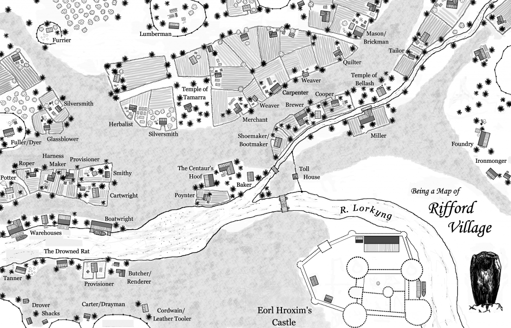
-
Landifarne
- Pathfinder
- Posts: 283
- Joined: Sat Oct 12, 2013 7:57 pm
- Location: Los Angeles (Miracle Mile)
Re: Campaign Region: Description; Background; Maps
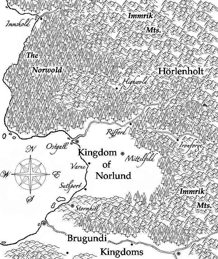
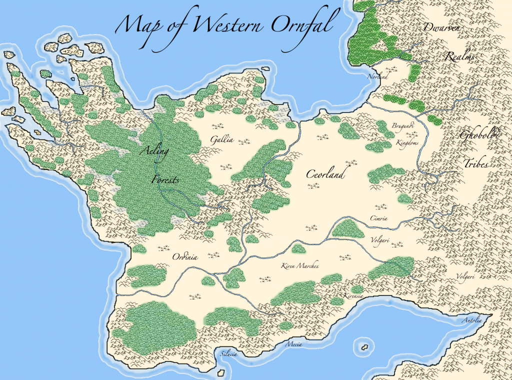
This is a map of Western Ornfal, giving an indication of where our campaign area is located (upper right corner). Norlund was established by disaffected nobles that sailed along the northern coasts of Ceorland and founded the small city of Ostgall some 150 years ago. They are typical (RL) Normans in character, and have traditional foes in the savage barbarians to the north- the Suevi, Juti and Friuli, and in the Brugundi petty kings to the south.
-
Landifarne
- Pathfinder
- Posts: 283
- Joined: Sat Oct 12, 2013 7:57 pm
- Location: Los Angeles (Miracle Mile)
Re: Campaign Region: Description; Background; Maps
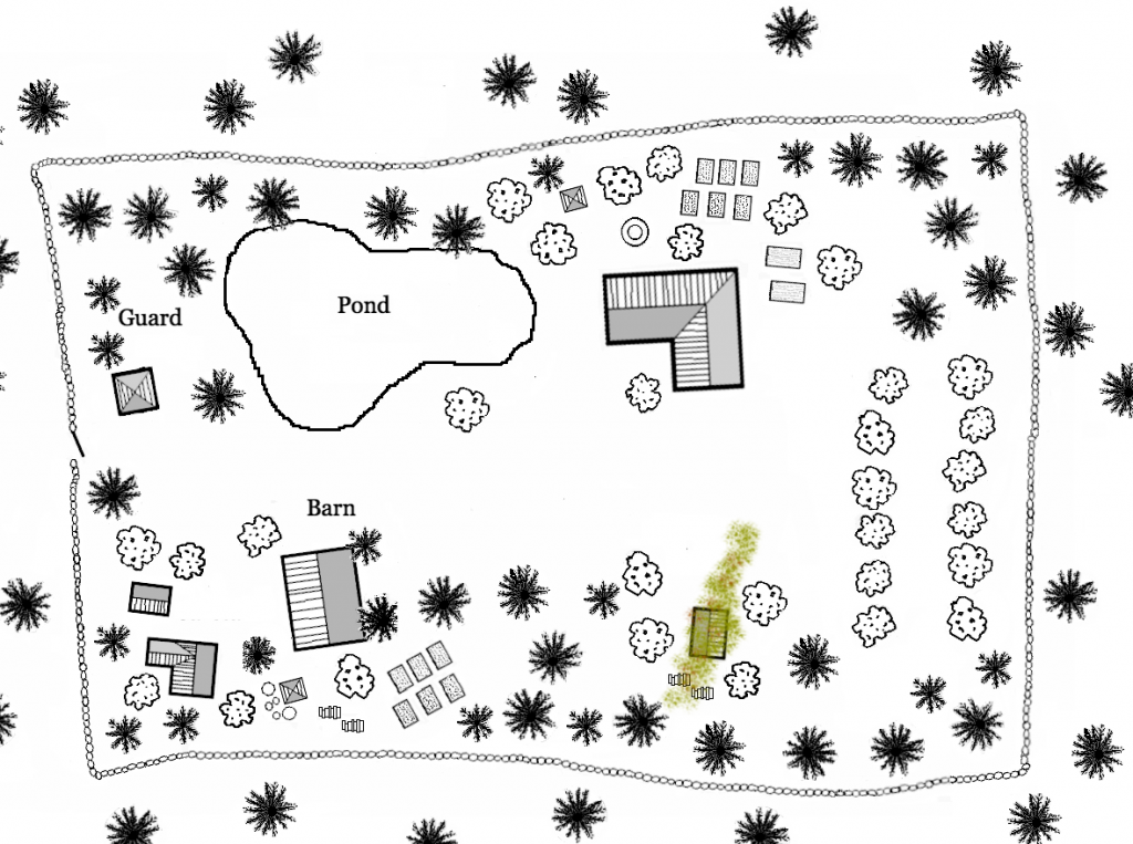
The map of Sanblic's estate supplied by the handler (the estate is half a league northeast of Rifford):